- Home
- China
- World
- Europe
- Politics
- Business
- Opinions
- Tech & Sci
- Culture
- Sports
- Travel
- Nature
- Picture
- Video
- Live
- TV
- Specials

Share

Copied
China has developed its own BeiDou Navigation System (BDS). And the technology it adopts also helps to improve applications in a number of different sectors.
Inside the testing facility of the National Key Laboratory of Navigation Satellite System and Equipment Technology, scientists are testing a new approach to improve indoor positioning.
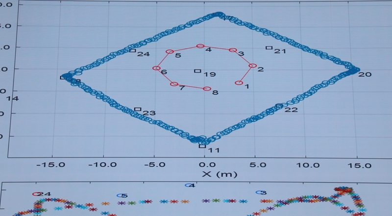
Using six pseudolites, the positioning accuracy can reach within 10 centimeters inside a building. A pseudolite is like a satellite in the sky, but it is based on the ground.
"It is a seamless positioning experience to go from the outside to inside a building installed with our pseudolites," said Yi Qingwu, deputy director of the National Key Lab.
It requires at least four pseudolites to determine an exact position, but the cost is nearly negligible. And when more of these are installed, the service becomes much more accurate than before.
Indoor positioning is still a challenge for scientists around the globe, and so far there has been no widely recognized solutions.
A positioning service may involve multiple technologies such as the Global Navigation Satellite System, or GNNS, WiFi, Bluetooth and even 5G. Scientists here are making the best use of these different solutions.
When the indoor positioning technology becomes more accurate and reliable, applications like android robots on wheels and flying drones will become much easier to navigate through complex indoor environments.
The application of this technology is extensive. It could also be used in shopping malls, airports, stadiums or underground facilities such as parking garages and pipe systems.
With the BDS nearly completed, and ground based enhanced navigation technology developing quickly, the improved accuracy of positioning technology will soon provide people with more useful and exact location information.
Unique features to support broader range
The BDS space segment is a hybrid navigation constellation consisting of satellites in three orbits – the Medium Earth Orbit, the Geostationary Orbit (GEO) and the Inclined GeoSynchronous Orbit (IGSO).
"This enables our country's navigation services to be extended globally, while providing better, higher-quality navigation and positioning services through GEO and IGSO in and around our country, as well as a variety of unique services," said Wang Ping, chief designer of BeiDou satellite from China Academy of Space Technology.
Another feature is that BDS has creatively combined navigation with communications functions. Users can now send messages choosing from over 1,000 Chinese characters.
This unique feature allows users to transmit information from any location in the world. People can know where they are, and also share their location information with others.
China has been actively optimizing BDS compatibility with the U.S.' GPS, Russia's Glonass and European Gelileo under the International Committee on Global Navigation Satellite Systems, as well as cooperating with countries along the Belt and Road, to improve the navigation services and expand coverage of digital applications.