- Home
- China
- World
- Asia-Pacific
- Americas
- Europe
- Middle-East and Africa
- Politics
- Business
- Opinions
- Tech & Sci
- Culture
- Sports
- Travel
- Nature
- Picture
- Video
- Live
- TV
- Radio
- Specials
- Learn Chinese

Share

Copied
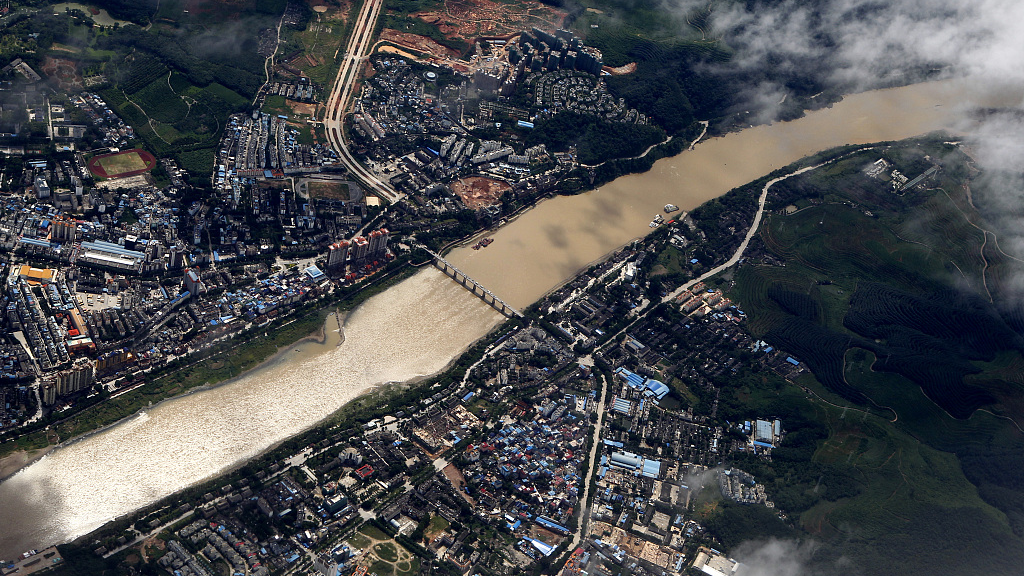
A bird's-eye view of Jinghong Dam on the Lancang River in Xishuangbanna Dai Autonomous Prefecture, Yunnan Province, southwest China. /CFP
Hydrological experts at China's Tsinghua University say reservoir level reports released by the U.S.-funded program "Mekong Dam Monitor (MDM)" were full of serious errors that can easily be misused in hyping up claims that Chinese dams "control water" and "hurt downstream countries," reported by Global Times on Wednesday.
The Chinese research team found that the data obtained by MDM's satellite remote measurements reverses the actual water level rise and fall trends of the Xiaowan Reservoir in at least three monitoring periods in 2020, with errors up to 14.84 meters, which is equivalent to some 2.4 billion cubic meters of water.
In response to the errors, MDM acknowledged on its Facebook page on Wednesday some mistakes including a serious "typo" in their data and made corrections after double-checking with high-resolution satellite imagery from Planet Labs, a professional platform.
However, even after the revision, experts from Tsinghua pointed out on Thursday that MDM's reading still has an error of up to eight meters from the actual water level measurement, for example, at the time point of April 8, 2020.
"An error of eight meters is roughly 1.2 billion cubic meters of water. The impacts for some downstream countries are obvious and worrisome," said the Chinese experts, adding that the errors could be misinterpreted as "Chinese dams intercepting water" and negatively hyped as evidence that "upstream dams are causing drought downstream."
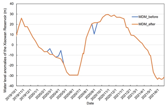
A comparison diagram of a water level reading of Xiaowan Reservoir given by Chinese experts from Tsinghua University. /Research team of Tsinghua University
Repeated errors in MDM data
The MDM, run by the U.S.-backed institution Stimson Center's Southeast Asia, started on December 15, 2020, and has since mounted persistent claims that attack on Chinese dams.
The program monitored the hydrological and climatic information, and the satellite aerial photographs and analysis of all 13 completed dams, including 11 in China, and reservoirs on the Mekong mainstream, in addition to 15 tributary dams on a weekly updated base. Observers said the errors were partly caused by backward tools and backdoor political considerations.
Nonetheless, this isn't the first time that deviations, even contradictions, in MDM results have been exposed.
In a Facebook post, MDM said that "there was a significant flow restriction of 144 cubic kilometers at the Jinghong Dam" during the week of January 31 to February 6. However, 144 cubic kilometers is ironically far larger than the storage capacity of the Jinghong Dam. Moreover, it is more than 1,000 times larger than the total water weekly released by all 45 dams in the basin.
In 2019-2020, MDM launched a high alert for a "China dam threat" by claiming that the drought in the lower Mekong region was due to China's upstream dams' withholding of water. However, its own results were embarrassingly contradictory.
Blaming China's reservoirs for withholding large amounts of water during the wet season (June-December 2019), MDM counted a drought downstream in China. But it further claimed that the wet season rainfall in Lancang River was larger than in previous years, while revealing two major Chinese reservoirs, Nuozhadu and Xiaowan, withheld significantly less water in the wet season than they had previously.
Ironically, according to MDM's logic, more rainfall but less storage in China's reservoirs should lead to drought alleviation downstream, not exacerbation. This shows that MDM's conclusions are contradictory and untenable, said the experts.
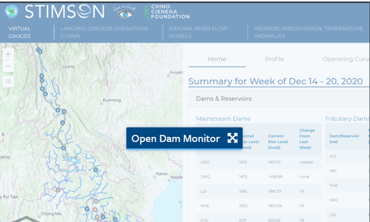
A screenshot of the official web page of the United States-funded project Mekong Dam Monitor (MDM).
Ulterior motives
Zhai Kun, an expert on the Mekong region with the School of International Studies at Peking University, said it is normal for upstream and downstream countries to have different, even conflicting, interests in the development and utilization of cross-border water resources. However, there is no serious water conflict among countries along the Lancang-Mekong River, contrary to some Western media reports and scholars.
The MDM is supported by the Mekong-U.S. Partnership, experts pointed out.
Ge Hongliang, deputy director of the College of ASEAN Studies at Guangxi University for Nationalities, said that the U.S. has ramped up its efforts in strengthening its participation in Indo-Pacific affairs, which are strategically significant to its national interests, through multilateral mechanisms such as Quad, the Mekong-U.S. Partnership and APEC.
MDM urged Chinese scientists to share more information about the Lancang reservoir levels on its Facebook post, but China has actually published its reservoirs' daily overall water release downstream since November 2020, and has insisted on reporting annual water discharge and relevant hydrological information to related countries.
Furthermore, China and countries along the lower Mekong River have also jointly conducted a study on hydrological and climate changes to pursue the best solutions to cope with the increasing natural threats.
For example, in September 2021, the Mekong River Commission, an intergovernmental body comprising Cambodia, Laos, Thailand and Vietnam, announced a three-year study spanning the entire river basin, in tandem with Myanmar and the China-led Lancang-Mekong Cooperation Water Center.