- Home
- China
- World
- Asia-Pacific
- Americas
- Europe
- Middle-East and Africa
- Politics
- Business
- Opinions
- Tech & Sci
- Culture
- Sports
- Travel
- Nature
- Picture
- Video
- Live
- TV
- Documentary
- Radio
- Specials
- Learn Chinese

Share

Copied
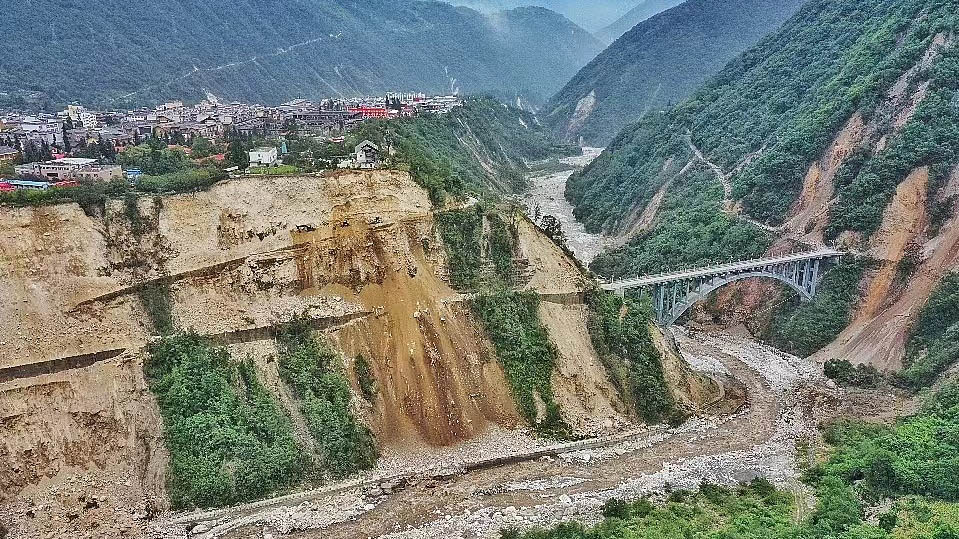
A landslide caused by the magnitude-6.8 earthquake in Luding County, southwest China's Sichuan Province. /CFP
A magnitude-6.8 earthquake hit Luding County, southwest China's Sichuan Province, on September 5, putting the topic of earthquakes in the region back in the headlines.
From 26 BC to the end of 2021, records show that Sichuan experienced 309 earthquakes with a magnitude of 5.0 or above (including the aftershocks of the devastating 2008 Wenchuan earthquake), 82 of which were recorded as magnitude 6.0 or above. The strongest struck in 2008, when a magnitude-8.0 earthquake rocked Wenchuan, a county in Ngawa Tibetan and Qiang Autonomous Prefecture in northwest Sichuan.
According to the Sichuan Earthquake Administration, the seismic activity in Sichuan is strong in the west and weak in the east, which coincides with Sichuan's topography – high in the west and low in the east.
With respect to geology, Sichuan can be seen as having two parts: the east is the Sichuan Basin, and the west is the Western Sichuan Plateau, characterized by mountain ranges forming the easternmost part of the Qinghai-Tibet Plateau. Movements between the two parts, or plates, have sowed many faults in the province.
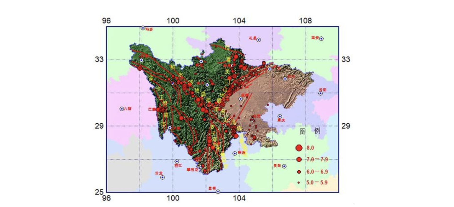
Distribution of earthquakes above M5.0 in Sichuan from 26 BC to the end of 2021. /Sichuan Earthquake Administration
The image above shows that most of the strong earthquakes in Sichuan are on the western Sichuan Plateau and its edge, with three major seismic belts forming a Y-shape.
Earthquakes mostly occur on faults due to rapid movement. The three seismic belts are linked by three main faults – the Anninghe fault to the south, the Longmenshan fault to the northeast and the Xianshuihe fault to the northwest.
These faults are rather active, and have created many strong earthquakes. For example, the M8.0 Wenchuan earthquake occurred along the Longmenshan fault, and the M6.8 earthquake that hit Luding County this month was in the Xianshuihe fault zone.
The Xianshuihe fault is considered as one of the most seismically active regions in mainland China. Since 1725, there have been eight powerful earthquakes of magnitude 7.0 or greater along the fault.

Preserved ruins of the 2008 Wenchuan earthquake. /CFP
Sichuan Province is not the only area of China experiencing frequent earthquakes, China's Taiwan region, provinces like Yunnan and Fujian, autonomous regions like Ningxia and Ganzu, and the northern part of North China all lie in earthquake-prone areas.
China sits in the southeastern part of Eurasia. The east is affected by the Circum-Pacific belt, the world's greatest earthquake belt, and the southwest and northwest are affected by the Alpide belt or Alpine-Himalayan orogenic belt. Besides Guizhou and Zhejiang, every Chinese province has experienced an earthquake above magnitude 6.0.
(If you want to contribute and have specific expertise, please contact us at nature@cgtn.com.)
Search Trends
Copyright © 2020 CGTN. 京ICP备16065310号

Disinformation report hotline: 010-85061466
Copyright © 2020 CGTN. 京ICP备16065310号
Disinformation report hotline: 010-85061466
Copyright © 2020 CGTN. 京ICP备16065310号
Disinformation report hotline: 010-85061466