
Politics
15:40, 25-Aug-2017
Ancient Japanese map shows Diaoyu Islands belong to China
Share

Copied
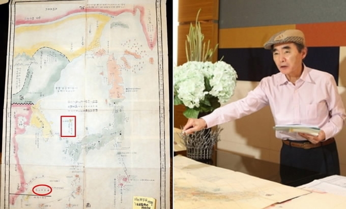
Japanese historian Norio Kuboi recently unveiled a collection of historical maps of Japan, showing that the Diaoyu Islands are inherent territories of China and the islets of Dokdo are in the sea of South Korea. He claims the historical map on the official website of Japan's Ministry of Foreign Affairs is "forged."
Kuboi announced the publishing of a Korean language translation of his book "Truth of Dokdo" on Tuesday in Busan, South Korea, while displaying the maps and the book "Illustrated Outline of the Three Countries" (San Guo Tong Lan Tu Shuo) written by Japanese scholar Hayashi Shihei.
According to "Illustrated Outline of the Three Countries," the Diaoyu Islands were painted the same color as China's mainland, while the Dokdo islets were painted the same as the Korean Peninsula.
The book was published in 1785, one of the earliest attempts to define Japan's outer boundaries in the Meiji period.
Kuboi said he collected the map book from bookstores in Tokyo and Osaka, hoping to explore historical facts and showing the Japanese government's distortion in the sovereignty of the Diaoyu Islands and the Dokdo islets.
The Japanese government has long refused to recognize the map but presented it to the US to prove that the Bonin Islands belong to Japan.
China's Foreign Ministry on Thursday reiterated China's position on the Diaoyu Islands, adding the evidence provided by the Japanese historian has proved once again that the Diaoyu Islands are inherent territories of China.
"China's sovereignty over Diaoyu Islands has solid historical and legal grounds," said Hua Chunying, spokesperson for the Foreign Ministry. "We urge the Japanese side to face the history squarely, respect the fact and properly handle the Diaoyu Islands issue."