
Tech & Sci
16:54, 25-Dec-2017
Earthquakes, not China, cause of river pollution in India
Share

Copied
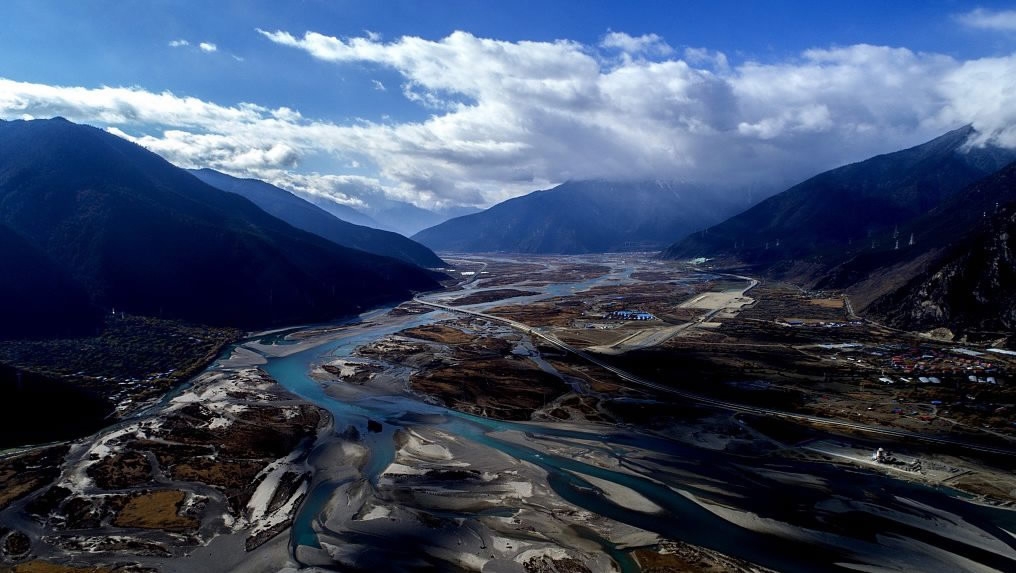
The mysterious “blackening” of the Siang River, which threatens to pollute major rivers like the Brahmaputra in Northeast India, is an outcome of a series of earthquakes, not infrastructure development by China, claims a study based on satellite images.
The large-scale death of fish and high turbidity in the water triggered panic and speculation in the region for the last month. A section of Indian politicians blamed China for polluting the Siang River that originates from Southwest China's Tibet Autonomous Region glacier.
The river travels for nearly 2,000 km within China before entering India. Last month, the river’s water suddenly turned blackish leaving scientists and politicians baffled.
Ripun Bora, a senior politician and member of India's upper house of Parliament, the Rajya Sabha, accused China's massive infrastructure construction near the river for turning the river’s water poisonous.
“There is an abnormal change of water in the Brahmaputra during the last one month, and poisonous, muddy, turbid water is flowing in this river. As a result, a lot of wild animals, aquatic life and have fish died,” he apprised the Rajya Sabha.
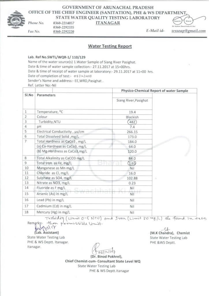
A government laboratory report reveals high turbidity in the Siang River. /Wiki Commons Photo
A government laboratory report reveals high turbidity in the Siang River. /Wiki Commons Photo
Series of earthquakes caused massive landslides
Chintan Sheth from India's National Centre for Biological Sciences and Anirban Datta-Roy, a doctoral student, told CGTN that an analysis of satellite images reveals that a series of earthquakes triggered massive landslides along the course of the river, which led to the severe pollution of its waters.
The Siang River, known as the Yarlung Zangbo River in China's Tibet Autonomous Region, runs through a sensitive seismic zone and a very delicate geographical formation.
The Gyala Peri mountain lies north of the Siang River and west of the Yigong Tsangpo river. Yarlung Tsangpo flows through a gorge at Gyala Peri and the Namcha Barwa mountain. The Siang then merges with the Yigong Tsangpo and from there takes a complete U-turn.
“A 6.4 magnitude earthquake struck below the summit of Gyala Peri on Nov. 17. Multiple earthquakes were recorded in the next 32 hours,” Sheth said. “Earthquakes led to landslides, and a large amount of debris collapsed into rivers darkening its waters.”
The river then merges with the Dibang and Lohit rivers in Assam to become the mighty Brahmaputra River.
The debris from the mountains and silt polluted the river to the extent that Nephelometric Turbidity Unit – a measure of the concentration of suspended particulates in a liquid went up to 425. The permissible turbidity for drinking water is around 5, a report by an Indian government laboratory claimed.
Researchers pointed out similar landslides were also recorded in April 2000. “The landslides had created an artificial dam holding a large amount of water,” Datta-Roy said.
“Our analysis revealed that the origin of the sediments is from Gyala Peri landslides. We do not have any evidence of the Chinese diverting water,” Sheth and Datta-Roy told CGTN.
High turbidity in the Siang River is also likely to affect Bangladesh in the next few weeks. High pollution in the river has wiped out aquatic life to a large extent affecting the local villages. Experts warned that pollution is already affecting China, India, and Bangladesh and concrete action is needed.
“There is a need for experts to figure out preventive and adaptation measures required for local farmers to deal with polluted waters. Farmers here are involved in fishing, shifting and terrace farming, and high turbidity in the water is destroying their livelihood,” Sheth and Datta-Roy added.
The speculation over China’s role in polluting the river had also forced the Chinese government to react. "This is untrue. This is a false report," Chinese Foreign Ministry spokesperson Hua Chunying told a media briefing when asked about the news report.