Satellite
20:21, 24-Jun-2018
Int'l oceanography satellite marks 10th year in orbit
CGTN

Originally designed for a three-to-five-year mission, a prolific international sea-observing satellite that is tracking the rise in global sea level marks its 10th year in orbit this week.
The US-European Ocean Surface Topography Mission on the Jason-2 satellite was launched in June 2008. Since then, it has made more than 47,000 trips around the Earth.
Its work includes measuring sea-level changes across the globe, observing ocean currents, studying climate phenomena such as El Nino and La Nina, and monitoring the long-term rise in the global mean sea level, according to US National Aeronautics and Space Administration (NASA).

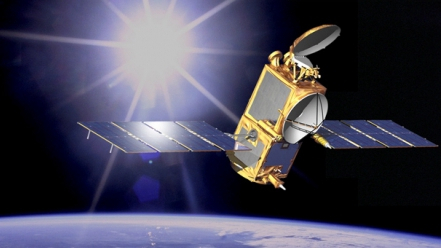
The work of the Jason-2 satellite includes measuring sea-level changes across the globe, observing ocean currents, studying climate phenomena and monitoring the long-term rise in the global mean sea level. /VCG Photo
The work of the Jason-2 satellite includes measuring sea-level changes across the globe, observing ocean currents, studying climate phenomena and monitoring the long-term rise in the global mean sea level. /VCG Photo
"The 10th anniversary of the launch of Jason-2 is also a landmark in the development of operational oceanography, as this was the first Jason mission involving two operational agencies, EUMETSAT and NOAA," Alain Ratier, director-general of the European Organization for the Exploitation of Meteorological Satellites (EUMETSAT), said in a statement.
EUMETSAT, the US National Oceanic and Atmospheric Administration (NOAA), NASA, the European Space Agency, and the French National Center for Space Studies are currently working on future generations of satellite altimeters, projected for launch in the next decade.
The launch of Jason-2 "paved the way for the transition from highly successful research missions to an operational altimeter system, which has now turned to reality with Jason-3, Jason-CS/Sentinel-6 and Sentinel-3 providing data until 2030," Ratier said.

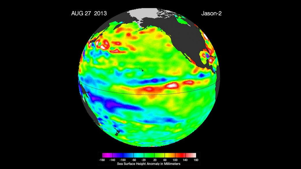
The image of sea surface heights in the Pacific Ocean in 2013 from NASA's Jason-2 satellite /NASA Photo
The image of sea surface heights in the Pacific Ocean in 2013 from NASA's Jason-2 satellite /NASA Photo
In January 2016, Jason-2 was joined in orbit by its follow-on mission, Jason-3.
"Along with Jason-3, Jason-2 has extended the record of global sea level rise into a third decade," Glenn Shirtliffe, Jason-2 project manager at NASA's Jet Propulsion Laboratory (JPL) in Pasadena, California, said. JPL manages NASA's portion of both missions.
In July 2017, Jason-2 began a new mission. It was manoeuvred into a slightly lower orbit, from where it has been collecting data along a series of very closely spaced ground tracks, just eight kilometers apart.
It will take over a year for the satellite to complete one cycle of these new ground tracks, which provide a very accurate and high-resolution estimate of the mean sea surface.
In addition to measuring ocean circulation and revealing the ocean's role in Earth's climate, Jason-2 and Jason-3 also measure the rise in the global sea level caused by global warming.
"Melting ice and expanding seawater drive global sea levels higher and higher each year. The rise has become a powerful reminder of how fast humans are changing the climate. These missions keep our finger on the pulse of climate change," Josh Willis, JPL oceanographer and NASA's project scientist for both missions, said.
Other significant results from the mission include studies of ocean circulation, the ties between the ocean and the atmosphere, and improved global climate forecasts and predictions.
(Top image: The Jason-2 satellite. /NASA Photo)
Source(s): Xinhua News Agency

SITEMAP
Copyright © 2018 CGTN. Beijing ICP prepared NO.16065310-3
Copyright © 2018 CGTN. Beijing ICP prepared NO.16065310-3