Share

Copied

Editor's note: "Shared by Nature" invites experts and scholars from around the world to share their knowledge of major issues in nature, such as climate change, biodiversity conservation and environmental protection. From the previous interview, we already know that Türkiye is surrounded by three seismic hazard zones: the East Anatolian Fault, the North Anatolian Fault and the Eastern Mediterranean Region. But precisely speaking, what are their main features? In this edition, we talked to Li Chuanzhi, a PhD candidate for geology at Ocean University of China and a content creator at Zhihu, to talk about Türkiye's seismic hazard zones.
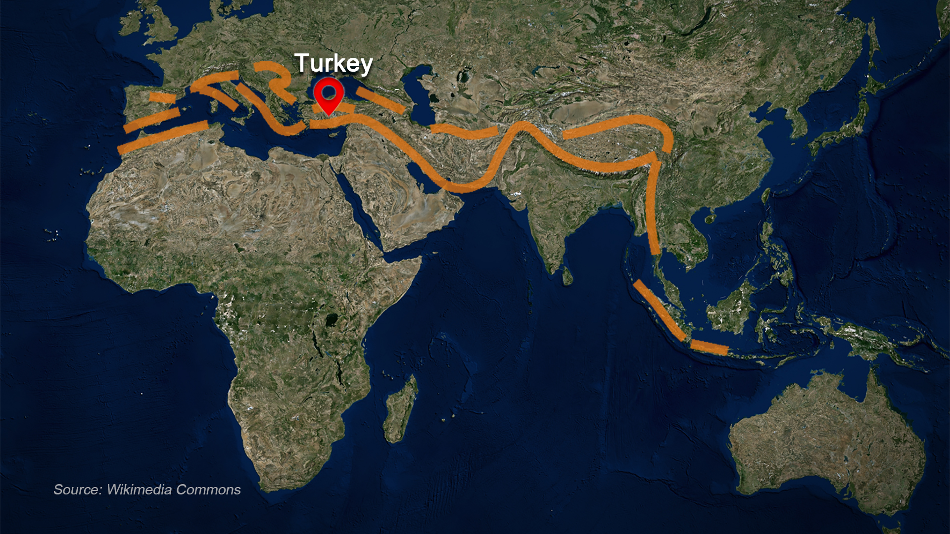
The Alpine-Himalayan orogenic belt. /Graphic by CGTN's Zhang Xuecheng
Türkiye has suffered from earthquakes for a long time and around 96 percent of its land lies on the Alpine-Himalayan orogenic belt. The Earth's lithosphere is divided into several tectonic plates, and the fault zones of these plate boundaries are seismic hazard areas. As Türkiye sits at the intersection of the Eurasian, African and Arabian plates, it is surrounded by the three seismic hazard zones, namely the Eastern Mediterranean Region, the East Anatolian Fault and the North Anatolian Fault.
The African plate to the southwest of Türkiye is continuously pushing the Eurasian plate at a speed of about 2 cm/year, forming the Eastern Mediterranean Region, a typical ocean trench with a high incidence of earthquakes.
The Arabian plate to the southeast of Türkiye enters eastern Türkiye like a wedge, forming the Turkish-Iranian plateau. It also pushes the Anatolian plate, where Türkiye sits, to the west, creating two main strike-slip faults to regulate the motion between the plates. They make up the North Anatolian Fault, which is a dextral strike-slip fault, and the East Anatolian Fault, which is a sinistral strike-slip fault. Many of Türkiye's catastrophic earthquakes were caused by the activities of these two faults.
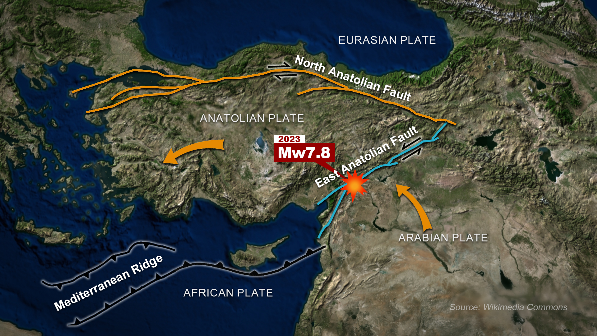
Türkiye's seismic hazard zones. /Graphic by CGTN's Zhang Xuecheng and Li Wenyi
The North Anatolian Fault, which runs through northern Türkiye, is recognized by international seismological research institutes as one of the most seismically active regions in the world. In 1999, a magnitude-7.4 earthquake struck western Türkiye, causing about 16,000 deaths and injuring more than 40,000 people.
The recent magnitude-7.8 earthquake occurred on the other fault at the southwest end of the East Anatolian Fault, which is near the boundary between three plates – the Arabian plate, the Eurasian plate and the African plate, or precisely, the Arabian, the Anatolian and the African plates.
Since 2023, the Alpine-Himalayan orogenic belt has been more active. For example, Indonesia has been hit by several devastating earthquakes this year, including a magnitude-7.6 quake on January 10 this year.
The western part of Iran, near Türkiye, has also been hit by three consecutive earthquakes of magnitude 5.5 or higher since January, causing thousands of casualties.
Whether this indicates that the Alpine-Himalayan orogenic belt is in a phase of concentrated release of seismic energy, or whether this earthquake in Türkiye can trigger earthquakes in other regions, is not clear yet. The situation requires further monitoring, studying and analyzing.
(Cover image by CGTN's Li Wenyi. Video edited by CGTN's Xing Fangyu and Xu Wen.)
(If you want to contribute and have specific expertise, please contact us at nature@cgtn.com.)
Search Trends
SITEMAP
Copyright © 2023 CGTN. 京ICP备16065310号

Disinformation report hotline: 010-85061466
SITEMAP
Copyright © 2023 CGTN. 京ICP备16065310号
Disinformation report hotline: 010-85061466